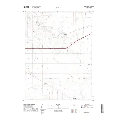
2021 Map of Franklin Grove
USGS Topo · Published 2021About this map
Franklin Grove and the surrounding agricultural landscape of Lee County are documented here through a dense network of local roads and waterways. The village is well-defined by its grid of streets, including S State St and S Walnut St, serving as a central hub for the outlying rural townships. Local history is grounded in the presence of several established burial grounds such as Franklin Grove Cem, Emmert Cem, and the distantly located Temperance Hill Cem to the south. The terrain is drained by Franklin Cr and Chamberlain Cr, which meander through a countryside marked by family-named infrastructure and early crossings. Notable landmarks include the curiously named Mondays Bridge and Sundays Bridge along Twist Rd, as well as the Gittleson Farms Airport situated among the expansive farm fields. The map also records the southern settlement of Lee Center, providing a detailed look at the infrastructure connecting these Illinois communities.
Find a feature on this map
46 named features on this map. Tap any name to fly to it.
Don’t see what you’re looking for? This feature index may not catch every label — zoom into the map to look around manually.
Map Details
Editions of this 2021 Franklin Grove Map
This is the sole edition of this map. No revisions or reprints were ever made.
Other maps of this area

1918 · Dixon
USGS Topo · 1:62,500

1950 · Dixon
USGS Topo · 1:62,500

1951 · Amboy
USGS Topo · 1:62,500

1952 · Rochelle
USGS Topo · 1:62,500

1952 · Mendota
USGS Topo · 1:62,500

1958 · Aurora
USGS Topo · 1:250,000

1961 · Aurora
USGS Topo · 1:250,000
1975 · Chana
USGS Topo · 1:24,000
1975 · Ashton
USGS Topo · 1:24,000
1982 · Sublette
USGS Topo · 1:24,000
Featured Places
- Franklin Grove, IL
- Ashton Township, IL
- Franklin Grove Township, IL
- Nachusa Township, IL
- Amboy Township, IL