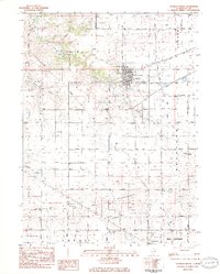
1983 Map of Franklin Grove
USGS Topo · Published 1984About this map
The village of Franklin Grove serves as the focal point of this 1980s Lee County landscape, situated where Franklin Creek and Chamberlain Creek converge. The street grid is well-defined, showing residential blocks centered around Atlanta Park and essential civic landmarks like the Franklin Center High Sch and a local post office. While the Illinois Tollway cuts through the northern sections, much of the surrounding area remains agricultural, organized into the historic townships of China, Nachusa, and Ashton.
Find a feature on this map
55 named features on this map. Tap any name to fly to it.
Don’t see what you’re looking for? This feature index may not catch every label — zoom into the map to look around manually.
Map Details
Editions of this 1983 Franklin Grove Map
This is the sole edition of this map. No revisions or reprints were ever made.
Other maps of this area

1918 · Dixon
USGS Topo · 1:62,500

1950 · Dixon
USGS Topo · 1:62,500

1951 · Amboy
USGS Topo · 1:62,500

1952 · Rochelle
USGS Topo · 1:62,500

1952 · Mendota
USGS Topo · 1:62,500

1958 · Aurora
USGS Topo · 1:250,000

1961 · Aurora
USGS Topo · 1:250,000
1975 · Chana
USGS Topo · 1:24,000
1975 · Ashton
USGS Topo · 1:24,000
1982 · Sublette
USGS Topo · 1:24,000
Featured Places
- Franklin Grove, IL
- Bradford Township, IL
- Nachusa Township, IL
- Amboy Township, IL
- Franklin Grove Township, IL