
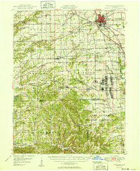
1950 Map of Franklin
USGS Topo · Published 1950About this map
Franklin serves as the focal point of this mid-century survey, showing the city's significant institutional growth through the Masonic Home, Greenlawn Cemetery, and the Johnson County Memorial Hospital. The landscape to the south is dominated by the Camp Atterbury Military Reservation, which includes a noted Prisoner of War Camp and Wakeman Hospital during this post-war era. The transportation network is defined by the intersection of the Pennsylvania Railroad and the Illinois Central Railroad, which facilitated the movement of goods and people between smaller rural hubs like Trafalgar, Nineveh, and Providence.
Find a feature on this map
105 named features on this map. Tap any name to fly to it.
Don’t see what you’re looking for? This feature index may not catch every label — zoom into the map to look around manually.
Map Details
Editions of this 1950 Franklin Map
2 editions found
Other maps of this area

1942 · Franklin
USGS Topo · 1:125,000

1942 · Columbus
USGS Topo · 1:125,000

1946 · Belmont
USGS Topo · 1:24,000

1947 · Nashville
USGS Topo · 1:24,000

1947 · Franklin
USGS Topo · 1:62,500

1948 · Franklin
USGS Topo · 1:24,000

1948 · Edinburg
USGS Topo · 1:24,000

1948 · New Bellsville
USGS Topo · 1:24,000

1948 · Trafalgar
USGS Topo · 1:24,000

1948 · Nineveh
USGS Topo · 1:24,000