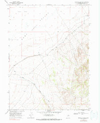
1968 Map of Franklin Lake SE
USGS Topo · Published 1990About this map
Ruby Valley dominates this high-desert landscape in northeastern Nevada, characterized by the stark expanse of the Alkali Flat. The topographic survey, based on 1965 aerial photography and field checked in 1968, details the drainage patterns of Ruby Wash as it descends from the surrounding highlands into the valley floor. The area is sparsely developed, with human activity represented primarily by a Jeep Trail and a lone Well, indicating a landscape focused on ranching or mineral exploration rather than dense settlement. The map serves as a primary source for the physical geography of this remote Great Basin depression during the late 1960s, showing the intersection of arid valley bottoms and the steep alluvial fans at the mountain base.
Find a feature on this map
5 named features on this map. Tap any name to fly to it.
Don’t see what you’re looking for? This feature index may not catch every label — zoom into the map to look around manually.
Map Details
Editions of this 1968 Franklin Lake SE Map
2 editions found
Other maps of this area

1955 · Elko
USGS Topo · 1:250,000

1958 · Elko
USGS Topo · 1:250,000

1962 · Elko
USGS Topo · 1:250,000

1965 · Elko
USGS Topo · 1:250,000

1968 · Franklin Lake SE
USGS Topo · 1:24,000

1968 · Franklin Lake SW
USGS Topo · 1:24,000

1968 · Franklin Lake NE
USGS Topo · 1:24,000
1968 · Ruby Lake NW
USGS Topo · 1:24,000

1968 · Ruby Lake NE
USGS Topo · 1:24,000
1969 · Franklin Lake NW
USGS Topo · 1:24,000