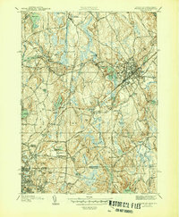
1946 Map of Franklin
USGS Topo · Published 1946About this map
Franklin serves as the hub of this 1940s landscape, where the New York New Haven and Hartford RR lines intersect near the historic Dean Academy campus. The surrounding terrain is a complex of wetlands and low hills, including Woodward Swamp and the prominent Joe's Rock to the south. Small industrial and residential clusters like Unionville, Wadsworth, and Sheldonville are connected by a developing road network, while the southern portion of the sheet crosses the state line into Rhode Island, reaching the northern edges of Woonsocket.
Find a feature on this map
84 named features on this map. Tap any name to fly to it.
Don’t see what you’re looking for? This feature index may not catch every label — zoom into the map to look around manually.
Map Details
Editions of this 1946 Franklin Map
3 editions found
Other maps of this area

1886 · Blackstone
USGS Topo · 1:62,500

1887 · Franklin
USGS Topo · 1:62,500

1887 · Providence
USGS Topo · 1:62,500

1889 · Providence
USGS Topo · 1:62,500

1889 · Blackstone
USGS Topo · 1:62,500

1889 · Franklin
USGS Topo · 1:62,500

1889 · Burrillville
USGS Topo · 1:62,500

1893 · Franklin
USGS Topo · 1:62,500

1893 · Blackstone
USGS Topo · 1:62,500

1894 · Burrillville
USGS Topo · 1:62,500