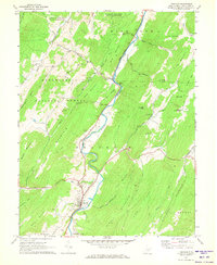
1969 Map of Franklin
USGS Topo · Published 1973About this map
The South Branch Potomac River winds through the heart of Pendleton County, anchoring the valley where the town of Franklin serves as a local hub. This late-1960s landscape shows a community deeply tied to its geography, with narrow strips of development following the river and its tributaries like Hammer Run and Trout Run. Cultural landmarks of the era include a Drive-in Theater and a Trailer Park north of town, illustrating mid-century social life and transit patterns along the valley floor.
Find a feature on this map
58 named features on this map. Tap any name to fly to it.
Don’t see what you’re looking for? This feature index may not catch every label — zoom into the map to look around manually.
Map Details
Editions of this 1969 Franklin Map
3 editions found
Other maps of this area

1892 · Franklin
USGS Topo · 1:125,000

1896 · Franklin
USGS Topo · 1:125,000

1920 · Petersburg
USGS Topo · 1:48,000

1920 · Onego
USGS Topo · 1:62,500

1921 · Petersburg
USGS Topo · 1:48,000

1921 · Onego
USGS Topo · 1:48,000

1922 · Onego
USGS Topo · 1:62,500

1922 · Fort Seybert
USGS Topo · 1:48,000

1922 · Petersburg
USGS Topo · 1:62,500

1922 · Circleville
USGS Topo · 1:62,500