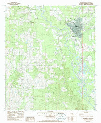
1983 Map of Franklinton
USGS Topo · Published 1986About this map
Franklinton serves as the focal point of this Washington Parish survey, where the street grid of the parish seat meets the winding course of the Bogue Chitto. The landscape is defined by its deep genealogical roots, illustrated by a remarkable concentration of family and community burial grounds including the Sweet Home Cem, Sweet Rest Cem, and Magee Cem. Surrounding the town, smaller settlements like Wildblood, Bonner, and Richardson anchor a rural terrain etched by numerous waterways such as Mile Branch and Stevens Creek. This 1980s data highlights the established religious and educational foundations of the area, featuring Bowling Green High Sch and rural congregations at Bellevue Ch and Bethel Ch. The map provides a clear record of the area's transition from concentrated town life to the creek-side family lands that have shaped this portion of Louisiana for generations.
Find a feature on this map
42 named features on this map. Tap any name to fly to it.
Don’t see what you’re looking for? This feature index may not catch every label — zoom into the map to look around manually.
Map Details
Editions of this 1983 Franklinton Map
2 editions found
Other maps of this area

1939 · Zona
USGS Topo · 1:31,680

1939 · Sunny Hill
USGS Topo · 1:31,680

1939 · Clifton
USGS Topo · 1:31,680

1942 · Husser
USGS Topo · 1:31,680

1942 · Thigpen
USGS Topo · 1:31,680

1942 · Wilmer
USGS Topo · 1:31,680

1942 · Thomas
USGS Topo · 1:31,680

1950 · Folsom
USGS Topo · 1:31,680

1950 · Franklinton
USGS Topo · 1:31,680

1954 · Folsom
USGS Topo · 1:62,500