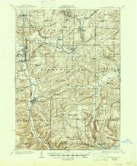
1924 Map of Franklinville
USGS Topo · Published 1947About this map
Franklinville serves as the central hub in this 1923 survey of northeastern Cattaraugus County, situated where Ischua Creek flows south toward the basin of Cuba Lake. The landscape is defined by its early 20th-century rural infrastructure, particularly a dense network of one-room schoolhouses like the Checkered School, Buffalo Road School, and Pigeon Hill School that once served the hilltop farming communities. The valley floor near Machias and Machias Junction shows the convergence of the Pennsylvania and Rochester Pittsburgh and Middleton railroads, which fueled the local economy and connected small hamlets like Elton Sta. and Farmersville Station to larger markets.
Find a feature on this map
92 named features on this map. Tap any name to fly to it.
Don’t see what you’re looking for? This feature index may not catch every label — zoom into the map to look around manually.
Map Details
Editions of this 1924 Franklinville Map
3 editions found
Other maps of this area

1898 · Olean
USGS Topo · 1:62,500

1900 · Salamanca
USGS Topo · 1:62,500

1905 · Portage
USGS Topo · 1:62,500

1906 · Angelica
USGS Topo · 1:62,500

1923 · Arcade
USGS Topo · 1:62,500

1924 · Ellicottville
USGS Topo · 1:62,500

1924 · Franklinville
USGS Topo · 1:62,500

1925 · Belmont
USGS Topo · 1:62,500

1925 · Springville
USGS Topo · 1:62,500

1925 · Arcade
USGS Topo · 1:62,500