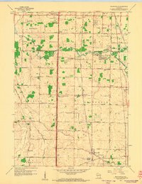
1958 Map of Franksville
USGS Topo · Published 1960About this map
Root River and Oak Creek define the drainage of this 1950s landscape, where the agricultural sections of Racine and Milwaukee Counties meet. The area is characterized by a precise grid of named thoroughfares, including Sixmile Road and Threemile Road, which connect rural hamlets and educational centers. Many of these crossroad communities, such as Kilbournville, Caledonia, and Thompsonville, serve as anchors for local life, supported by numerous country schools like Lafayette Sch and Hunter Sch.
Find a feature on this map
55 named features on this map. Tap any name to fly to it.
Don’t see what you’re looking for? This feature index may not catch every label — zoom into the map to look around manually.
Map Details
Editions of this 1958 Franksville Map
4 editions found
Other maps of this area

1891 · Bayview
USGS Topo · 1:62,500

1891 · Muskego
USGS Topo · 1:62,500

1892 · Racine
USGS Topo · 1:62,500

1893 · Silver Lake
USGS Topo · 1:62,500

1901 · Bayview
USGS Topo · 1:62,500

1901 · Muskego
USGS Topo · 1:62,500

1905 · Racine
USGS Topo · 1:62,500

1906 · Silver Lake
USGS Topo · 1:62,500

1954 · Rockford
USGS Topo · 1:250,000

1955 · Rockford
USGS Topo · 1:250,000