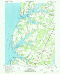
1968 Map of Franktown
USGS Topo · Published 1971About this map
Church Neck and Wilsonia Neck define this portion of the Eastern Shore, where the intricate tidal systems of the Chesapeake Bay meet a landscape of old estates and rural crossroads. In the late 1960s, the Penn Central corridor served as the primary terrestrial spine, connecting local hubs like Machipongo and Birdsnest. The map reveals a high density of religious and educational landmarks important for genealogy, including Hungars Ch near Bridgetown and Antioch Ch in Treherneville.
Find a feature on this map
64 named features on this map. Tap any name to fly to it.
Don’t see what you’re looking for? This feature index may not catch every label — zoom into the map to look around manually.
Map Details
Editions of this 1968 Franktown Map
Other maps of this area

1942 · Cheriton
USGS Topo · 1:24,000

1942 · Cobb Island
USGS Topo · 1:24,000

1942 · Nassawadox
USGS Topo · 1:24,000

1943 · Nassawadox
USGS Topo · 1:31,680

1943 · Jamesville
USGS Topo · 1:31,680

1943 · Franktown
USGS Topo · 1:31,680

1943 · Exmore
USGS Topo · 1:24,000

1943 · Richmond
USGS Topo · 1:250,000

1944 · Exmore
USGS Topo · 1:31,680

1946 · Eastville
USGS Topo · 1:250,000