1915 Map of Frazer
USGS Topo · Published 1949About this map
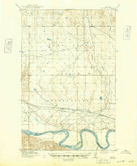
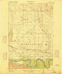
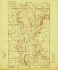
The Fort Peck Indian Reservation dominates this landscape along the northern banks of the Missouri River during the early twentieth century. This survey, conducted primarily between 1908 and 1913, reveals a period of significant infrastructure development in Northeast Montana. The Great Northern railroad tracks parallel the river, serving the nascent rail towns of Frazer and Kintyre. These settlements are situated on the benchlands above the river's flood plain, positioned to capitalize on the shipping corridor.
Find a feature on this map
10 named features on this map. Tap any name to fly to it.
Don’t see what you’re looking for? This feature index may not catch every label — zoom into the map to look around manually.
Map Details
Editions of this 1915 Frazer Map
3 editions found
Other maps of this area

1910 · Todd Lakes
USGS Topo · 1:62,500

1914 · Nashua
USGS Topo · 1:62,500

1915 · Frazer
USGS Topo · 1:62,500

1915 · Oswego
USGS Topo · 1:62,500

1915 · Todd Lakes
USGS Topo · 1:62,500

1915 · Spring Creek
USGS Topo · 1:62,500

1916 · Nashua
USGS Topo · 1:62,500
1918 · Porcupine Valley
USGS Topo · 1:62,500

1954 · Jordan
USGS Topo · 1:250,000

1954 · Glendive
USGS Topo · 1:250,000