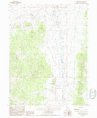
1986 Map of Frazier Creek
USGS Topo · Published 1986About this map
Garden Valley forms a broad corridor through this high-desert landscape in central Nevada, situated between the Roberts Mountains to the west and the Sulphur Spring Range to the east. The terrain is marked by the presence of a defunct transportation corridor, the Old Railroad Grade, which parallels the base of the mountains alongside Henderson Creek. Water sources are sparse but critical in this environment, with locations like Rabbit Spring and McCloud Spring appearing near the mountain slopes. Economic activity in the mid-1980s was primarily focused on extraction and exploration, as evidenced by several Prospects, a Gravel Pit, and a specific Mineshaft located near the southern boundary. The map captures a moment when the regional hydrology of Frazier Creek and its surrounding peaks remained relatively undeveloped, preserving the original traces of early mining and rail infrastructure.
Find a feature on this map
16 named features on this map. Tap any name to fly to it.
Don’t see what you’re looking for? This feature index may not catch every label — zoom into the map to look around manually.
Map Details
Editions of this 1986 Frazier Creek Map
This is the sole edition of this map. No revisions or reprints were ever made.
Other maps of this area

1926 · Roberts Mountains
USGS Topo · 1:250,000

1929 · Roberts Mountains
USGS Topo · 1:250,000

1937 · Mineral Hill
USGS Topo · 1:48,000

1943 · Mineral Hill
USGS Topo · 1:62,500

1949 · Garden Valley
USGS Topo · 1:62,500

1949 · Roberts Creek Mtn
USGS Topo · 1:62,500

1951 · Roberts Creek Mtn
USGS Topo · 1:62,500

1951 · Garden Valley
USGS Topo · 1:62,500

1955 · Millett
USGS Topo · 1:250,000

1955 · Winnemucca
USGS Topo · 1:250,000