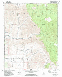
1957 Map of Frazier Valley
USGS Topo · Published 1994About this map
Frazier Valley and the Rocky Hills define this landscape of the mid-20th century, where the transition from the valley floor to the Sierra foothills is marked by a network of water management features and cattle-raising history. Cattle operations are anchored by Spanish Camp, while the presence of a Cemetery and various Prospects suggests earlier homesteading and mineral exploration efforts. The drainage patterns of Lewis Creek, Frazier Creek, and Campbell Creek are interrupted by numerous Reservoir sites and Spring developments, indicating the intensive water management required for local ranching. While the Frazier Highway provides the primary route through the southern valley, much of the higher ground in Oat Canyon and Yokohl Valley is accessible only by unimproved roads and trails, preserving a snapshot of Tulare County ranch land as it was in the late 1950s.
Find a feature on this map
23 named features on this map. Tap any name to fly to it.
Don’t see what you’re looking for? This feature index may not catch every label — zoom into the map to look around manually.
Map Details
Editions of this 1957 Frazier Valley Map
4 editions found
Other maps of this area

1904 · Kaweah
USGS Topo · 1:125,000

1909 · Kaweah
USGS Topo · 1:125,000

1925 · Rocky Hill
USGS Topo · 1:31,680

1927 · Rocky Hill
USGS Topo · 1:31,680

1928 · Lindsay
USGS Topo · 1:31,680

1929 · Porterville
USGS Topo · 1:31,680

1937 · Kaweah
USGS Topo · 1:125,000
1942 · Porterville
USGS Topo · 1:62,500

1948 · Fresno
USGS Topo · 1:250,000
1951 · Porterville
USGS Topo · 1:24,000