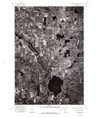
1974 Map of Frederic SE
USGS Topo · Published 1976About this map
The Wisconsin Geological and Natural History Survey and the U.S. Geological Survey produced this orthophotoquad through aerial photography captured in late 1974. Unlike a traditional topographic map with contour lines and color-coded land use symbols, this sheet provides a direct overhead view of the glacial landscape, revealing the complex distribution of woodlots and agricultural fields in northwestern Wisconsin. The photographic detail allows for a precise examination of the era's land management and forest density. While few named features are printed on this specific sheet beyond the primary transport artery of Highway 48, the imagery clearly shows the intricate pattern of kettles and small lakes characteristic of the region's topography. The orthophoto format preserves the exact footprint of farmsteads and rural roads as they existed in the mid-1970s, making it a distinctive resource for comparing modern land development with the rural character of the period.
Find a feature on this map
1 named feature on this map. Tap any name to fly to it.
Don’t see what you’re looking for? This feature index may not catch every label — zoom into the map to look around manually.
Map Details
Editions of this 1974 Frederic SE Map
This is the sole edition of this map. No revisions or reprints were ever made.
Other maps of this area

1950 · Balsam Lake
USGS Topo · 1:62,500

1950 · Turtle Lake
USGS Topo · 1:62,500

1951 · Cumberland
USGS Topo · 1:48,000

1951 · Frederic
USGS Topo · 1:48,000

1952 · Turtle Lake
USGS Topo · 1:62,500

1953 · Stillwater
USGS Topo · 1:250,000

1955 · Frederic
USGS Topo · 1:62,500

1955 · Stillwater
USGS Topo · 1:250,000

1956 · Cumberland
USGS Topo · 1:62,500

1958 · Stillwater
USGS Topo · 1:250,000