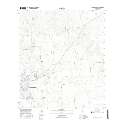
2016 Map of Fredericksburg East
USGS Topo · Published 2016About this map
Fredericksburg expands eastward into a landscape defined by rolling hills and intricate waterways in this mid-2010s survey. The northeastern edge of the settlement is anchored by Greenwood Cem, while the surrounding terrain is marked by distinctive elevations named for local families, including Kneese Hill, Schuetzen Hill, and the Kordzik Hills. To the northwest, the prominent Cross Mtn and Bear Mtn—the latter featuring Balanced Rock—overlook the valley floor.
Find a feature on this map
153 named features on this map. Tap any name to fly to it.
Don’t see what you’re looking for? This feature index may not catch every label — zoom into the map to look around manually.
Map Details
Editions of this 2016 Fredericksburg East Map
This is the sole edition of this map. No revisions or reprints were ever made.
Other maps of this area

1894 · Fredericksburg
USGS Topo · 1:125,000

1954 · Llano
USGS Topo · 1:250,000

1955 · Llano
USGS Topo · 1:250,000

1956 · Llano
USGS Topo · 1:250,000

1961 · Stonewall
USGS Topo · 1:24,000

1961 · Cave Creek School
USGS Topo · 1:24,000

1963 · Cain City
USGS Topo · 1:24,000

1964 · Oak Crest Park
USGS Topo · 1:24,000
1967 · Cherry Mountain
USGS Topo · 1:24,000

1967 · Fredericksburg East
USGS Topo · 1:24,000