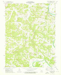
1974 Map of Fredericksburg
USGS Topo · Published 1976About this map
The Gasconade River winds through the heart of Osage County, defining a landscape shaped by both water and mineral extraction. The small settlement of Fredericksburg sits near the river's edge, supported by the Fredericksburg Ch and the neighboring Fredericksburg Ch. This mid-1970s survey reveals an economy deeply tied to the earth, evidenced by the numerous Claypit and Claypits scattered across the township lines of Benton, Crawford, and Boulware. Genealogists will find a high density of family-named burial grounds, including the Wilhoit Cem, Berry Cem, and Plattners Cem, often located on high ground away from the floodplains of Richland Creek and Baileys Creek. The mapping of a Ferry crossing and the prominent Heckman Bend underscores the river's historic role as a primary corridor before modern bridge networks fully superseded these traditional water crossings.
Find a feature on this map
43 named features on this map. Tap any name to fly to it.
Don’t see what you’re looking for? This feature index may not catch every label — zoom into the map to look around manually.
Map Details
Editions of this 1974 Fredericksburg Map
This is the sole edition of this map. No revisions or reprints were ever made.
Other maps of this area

1890 · Fulton
USGS Topo · 1:125,000

1934 · Linn
USGS Topo · 1:48,000

1934 · Bland
USGS Topo · 1:62,500

1935 · Morrison
USGS Topo · 1:48,000

1937 · Bland
USGS Topo · 1:62,500

1942 · Linn
USGS Topo · 1:62,500

1942 · Morrison
USGS Topo · 1:62,500

1945 · Mokane
USGS Topo · 1:62,500

1945 · Morrison
USGS Topo · 1:62,500

1945 · Linn
USGS Topo · 1:62,500