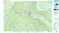
1983 Map of Fredericksburg
USGS Topo · Published 1984About this map
Fredericksburg-Spotsylvania National Military Park dominates the central portion of this 1980s landscape, preserving the geography of one of the most contested regions of the American Civil War. The map details a complex network of waterways where the Rappahannock River and Rapidan River meet, flowing toward the broad reaches of the Potomac River near Mathias Point Neck. The transition from rural crossroad settlements like Chancellor and Wilderness to the expansive waters of Lake Anna in the southwest reflects the evolving land use of late-twentieth-century Virginia.
Find a feature on this map
97 named features on this map. Tap any name to fly to it.
Don’t see what you’re looking for? This feature index may not catch every label — zoom into the map to look around manually.
Map Details
Editions of this 1983 Fredericksburg Map
2 editions found
Other maps of this area

1887 · Spottsylvania
USGS Topo · 1:125,000

1889 · Fredericksburg
USGS Topo · 1:125,000

1890 · Goochland
USGS Topo · 1:125,000

1890 · Mt. Vernon
USGS Topo · 1:125,000

1891 · Palmyra
USGS Topo · 1:125,000

1891 · Mt. Vernon
USGS Topo · 1:125,000

1892 · Fredericksburg
USGS Topo · 1:125,000

1892 · Spottsylvania
USGS Topo · 1:125,000

1892 · Goochland
USGS Topo · 1:125,000

1892 · Brandywine
USGS Topo · 1:62,500