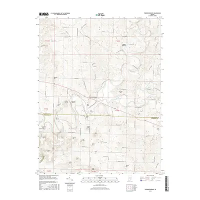
2016 Map of Fredericksburg
USGS Topo · Published 2016About this map
The Blue River carves a winding path through this portion of the Mitchell Plain, defining the border between Washington and Harrison counties. The settlement of Fredericksburg sits at a strategic crossing point, surrounded by family-named terrain features like Greene Mill Hill and Whittman Bottom. To the northeast, Organ Springs marks a smaller concentration of activity, while the landscape elsewhere is dotted with local heritage markers such as Boston Cem, Reno Cem, and Voyles Cem. The topography is characterized by numerous knobs and hollows, including Wildcat Knob and Haiti Hollow, which are linked by a dense network of rural roads such as S Fredericksburg Depauw Rd and W Mount Carmel Rd. The presence of the Jacobi Airport and Hunter Spring further highlights the mix of modern utility and natural geography in this southern Indiana corridor.
Find a feature on this map
104 named features on this map. Tap any name to fly to it.
Don’t see what you’re looking for? This feature index may not catch every label — zoom into the map to look around manually.
Map Details
Editions of this 2016 Fredericksburg Map
This is the sole edition of this map. No revisions or reprints were ever made.
Other maps of this area

1946 · Depauw
USGS Topo · 1:24,000

1947 · Hardinsburg
USGS Topo · 1:24,000

1948 · Milltown
USGS Topo · 1:24,000

1949 · Hardinsburg
USGS Topo · 1:24,000

1950 · Salem
USGS Topo · 1:24,000

1950 · Becks Mill
USGS Topo · 1:24,000

1950 · Palmyra
USGS Topo · 1:24,000

1953 · Fredericksburg
USGS Topo · 1:24,000
1954 · Crandall
USGS Topo · 1:24,000

1956 · Vincennes
USGS Topo · 1:250,000