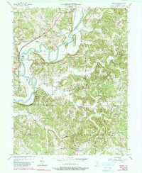
1956 Map of Freedom
USGS Topo · Published 1983About this map
The White River carves a winding path through the borderlands of Owen and Greene counties, defining a landscape of sharp ridges and rural outposts. Freedom serves as the primary riverside settlement, while the Conrail line and Harrison Highway track the movement of goods and people across the northern reaches of the quadrangle. The map is particularly notable for its high density of family and community burial grounds, such as Light Cem, White Cem, and Defore Cem, which signal a long-established agricultural population across Franklin and Clay townships. These small landmarks, alongside crossroads like Pottersville and Newark, provide a detailed record of the mid-century social geography before modern infrastructure bypassed these earlier hubs. To the south, the topography shifts into the prominent elevations of Stokey Ridge and Beech Creek, where the drainage of Raccoon Creek and Richland Creek creates a complex network of valleys.
Find a feature on this map
47 named features on this map. Tap any name to fly to it.
Don’t see what you’re looking for? This feature index may not catch every label — zoom into the map to look around manually.
Map Details
Editions of this 1956 Freedom Map
5 editions found

Other maps of this area

1908 · Bloomington
USGS Topo · 1:48,000

1908 · Bloomfield
USGS Topo · 1:62,500

1910 · Bloomington
USGS Topo · 1:62,500

1947 · Gosport
USGS Topo · 1:24,000

1950 · Gosport
USGS Topo · 1:24,000

1950 · Arney
USGS Topo · 1:24,000

1951 · Bloomfield
USGS Topo · 1:24,000

1953 · Indianapolis
USGS Topo · 1:250,000

1956 · Indianapolis
USGS Topo · 1:250,000

1956 · Patricksburg
USGS Topo · 1:24,000