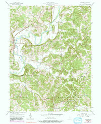
1956 Map of Freedom
USGS Topo · Published 1991About this map
The White River meanders sharply through the heart of Franklin and Clay townships, creating a landscape defined by deep river bends and high overlooks. Along its banks, the settlement of Freedom serves as a primary local hub, while smaller crossroads like Pottersville and Braysville dot the upland terrain. This mid-century survey documents a transition in transportation, showing the Conrail rail line and the Harrison Memorial Highway cutting through the river valley.
Find a feature on this map
48 named features on this map. Tap any name to fly to it.
Don’t see what you’re looking for? This feature index may not catch every label — zoom into the map to look around manually.
Map Details
Editions of this 1956 Freedom Map
5 editions found

Other maps of this area

1908 · Bloomington
USGS Topo · 1:48,000

1908 · Bloomfield
USGS Topo · 1:62,500

1910 · Bloomington
USGS Topo · 1:62,500

1947 · Gosport
USGS Topo · 1:24,000

1950 · Gosport
USGS Topo · 1:24,000

1950 · Arney
USGS Topo · 1:24,000

1951 · Bloomfield
USGS Topo · 1:24,000

1953 · Indianapolis
USGS Topo · 1:250,000

1956 · Indianapolis
USGS Topo · 1:250,000

1956 · Patricksburg
USGS Topo · 1:24,000