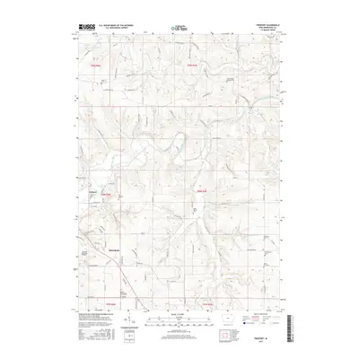
2015 Map of Freeport
USGS Topo · Published 2015About this map
The Upper Iowa River winds through this Winneshiek County landscape, carving a deep valley that defines the local geography. Adjacent to the city of Decorah, the settlement of Freeport sits at a critical bend in the river, showing the proximity between established municipal centers and smaller rural communities. The map is a significant resource for genealogists, as it identifies numerous family and community burial sites, such as the Canoe Ridge Lutheran Cem and Pontoppidan Cem, alongside smaller markers like the Teslow Farm Cem. The terrain is further characterized by the convergence of several waterways, including the Trout River and Canoe Creek, which feed into the larger river system. Modern infrastructure is represented by the Decorah Municipal Airport on the plateau southwest of the river valley, while a dense network of country roads like Canoe Ridge Rd and River Rd connect the various townships.
Find a feature on this map
81 named features on this map. Tap any name to fly to it.
Don’t see what you’re looking for? This feature index may not catch every label — zoom into the map to look around manually.
Map Details
Editions of this 2015 Freeport Map
This is the sole edition of this map. No revisions or reprints were ever made.
Other maps of this area

1906 · Decorah
USGS Topo · 1:125,000

1958 · La Crosse
USGS Topo · 1:250,000

1961 · La Crosse
USGS Topo · 1:250,000

1965 · La Crosse
USGS Topo · 1:250,000
1971 · Dorchester
USGS Topo · 1:24,000
1971 · Frankville
USGS Topo · 1:24,000
1971 · Hanover
USGS Topo · 1:24,000

1975 · Decorah 4 NW
USGS Topo · 1:24,000

1975 · Decorah 1 NW
USGS Topo · 1:24,000

1975 · Decorah 1 SW
USGS Topo · 1:24,000