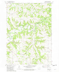
1981 Map of Freeport
USGS Topo · Published 1982About this map
Upper Iowa River meanders through the heart of this Winneshiek County landscape, carving deep loops through the terrain of Pleasant and Glenwood townships. The settlement of Freeport serves as a local hub near the river's edge, surrounded by recreation and conservation sites like the Upper Iowa River Access Area and Merlin Moe Park. The distribution of rural landmarks suggests a long-established agricultural community, with numerous family and congregation-linked sites such as Pioneer Cem, North Washington Prairie Cem, and Pontoppidan Cem dotting the countryside. To the south, the Decorah Municipal Airport and Oneota Country Club reflect the mid-century expansion of local infrastructure. Natural features define the area's character, from the winding path of Canoe Creek to the geological interests at Glenwood Cave and the many springs feeding the river system.
Find a feature on this map
35 named features on this map. Tap any name to fly to it.
Don’t see what you’re looking for? This feature index may not catch every label — zoom into the map to look around manually.
Map Details
Editions of this 1981 Freeport Map
This is the sole edition of this map. No revisions or reprints were ever made.
Other maps of this area

1906 · Decorah
USGS Topo · 1:125,000

1958 · La Crosse
USGS Topo · 1:250,000

1961 · La Crosse
USGS Topo · 1:250,000

1965 · La Crosse
USGS Topo · 1:250,000
1971 · Dorchester
USGS Topo · 1:24,000
1971 · Frankville
USGS Topo · 1:24,000
1971 · Hanover
USGS Topo · 1:24,000

1975 · Decorah 4 NW
USGS Topo · 1:24,000

1975 · Decorah 1 NW
USGS Topo · 1:24,000

1975 · Decorah 1 SW
USGS Topo · 1:24,000