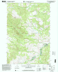
1997 Map of Freezeout Mountain
USGS Topo · Published 2002About this map
High-altitude grazing and timber management define this section of the Beaverhead National Forest as it was documented in the late 1990s. The landscape is marked by a series of high-country work sites including Miller Cow Camp, Partridge Cow Camp, and Sloan Cow Camp, which indicate the continued importance of seasonal livestock operations in the Madison Range. Drainage patterns are complex, with the Madison River and its West Fork cutting through the southeast, while northern slopes are fed by Gazelle Creek and Soap Creek. Elevation changes are dramatic, climbing from the riverbanks to the summit of Freezeout Mountain and the broad expanse of Lobo Mesa. Remote water sources such as the Secret Lakes and Freezeout Lakes provide focal points along the primitive forest road system, including Gazelle Road and Freezeout Road.
Find a feature on this map
25 named features on this map. Tap any name to fly to it.
Don’t see what you’re looking for? This feature index may not catch every label — zoom into the map to look around manually.
Map Details
Editions of this 1997 Freezeout Mountain Map
This is the sole edition of this map. No revisions or reprints were ever made.
Other maps of this area

1950 · Cliff Lake
USGS Topo · 1:62,500

1950 · Lower Red Rock Lake
USGS Topo · 1:62,500

1950 · Monument Ridge
USGS Topo · 1:62,500

1950 · Upper Red Rock Lake
USGS Topo · 1:62,500

1955 · Ashton
USGS Topo · 1:250,000

1958 · Ashton
USGS Topo · 1:250,000

1960 · Ashton
USGS Topo · 1:250,000
1988 · Granite Mountain
USGS Topo · 1:24,000
1988 · Bighorn Mountain
USGS Topo · 1:24,000
1988 · Hidden Lake Bench
USGS Topo · 1:24,000