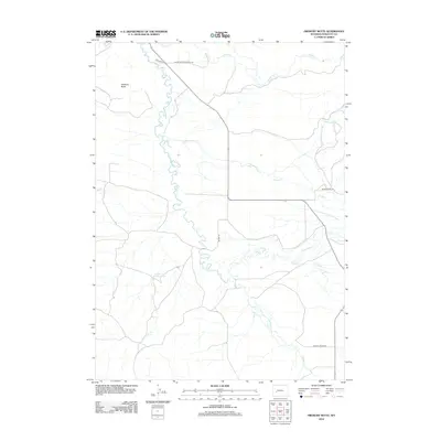
2012 Map of Fremont Butte
USGS Topo · Published 2012About this map
Fremont Butte rises above a high-plains landscape defined by a complex drainage network in Sublette County, where the E Fork River and its numerous tributaries like Silver Cr, Cottonwood Cr, and Muddy Cr converge. The topography is marked by the winding channels of these watercourses, which historically dictated the placement of early ranching infrastructure and trails. Local roads often carry the names of early settling families or geographical landmarks, such as Martin Jensen Rd and Pocket Creek Rd. A notable point for historical research is the Silver Creek Cemetery Rd, which hints at the locations of early burials and pioneer community centers. The presence of the Lander Cutoff Reservoir provides a reference to the historic westward migration route that once traversed this part of the Wyoming frontier.
Find a feature on this map
12 named features on this map. Tap any name to fly to it.
Don’t see what you’re looking for? This feature index may not catch every label — zoom into the map to look around manually.
Map Details
Editions of this 2012 Fremont Butte Map
This is the sole edition of this map. No revisions or reprints were ever made.
Other maps of this area

1938 · Mt Bonneville
USGS Topo · 1:62,500

1941 · Mt Bonneville
USGS Topo · 1:62,500

1942 · Mt Bonneville
USGS Topo · 1:62,500

1955 · Lander
USGS Topo · 1:250,000

1958 · Lander
USGS Topo · 1:250,000

1961 · Lander
USGS Topo · 1:250,000

1964 · Fremont Butte
USGS Topo · 1:24,000
1964 · Square Top
USGS Topo · 1:24,000

1964 · Boulder Lake
USGS Topo · 1:24,000

1964 · Boulder
USGS Topo · 1:24,000