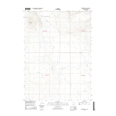
2015 Map of Fremont Butte
USGS Topo · Published 2015About this map
Fremont Butte rises above the high-desert terrain of Sublette County, where the meandering East Fork River and Cottonwood Cr dictate the movement of both water and cattle. This 2015 survey shows a landscape defined by ranching heritage and geographic landmarks, notably the Steele Hot Springs and the Lander Cut-off Reservoir. The road network provides evidence of early settlement and land use, with family-named routes such as Martin Jensen Rd and specialized paths like Silver Creek Cemetery Rd branching off from State Highway 353. The drainage patterns of Silver Cr, Pocket Cr, and Muddy Cr reveal the natural irrigation of the Wyoming basin, while the presence of the Lander Cut-off suggests the historical importance of western migration trails in this high-altitude cattle country.
Find a feature on this map
19 named features on this map. Tap any name to fly to it.
Don’t see what you’re looking for? This feature index may not catch every label — zoom into the map to look around manually.
Map Details
Editions of this 2015 Fremont Butte Map
This is the sole edition of this map. No revisions or reprints were ever made.
Other maps of this area

1938 · Mt Bonneville
USGS Topo · 1:62,500

1941 · Mt Bonneville
USGS Topo · 1:62,500

1942 · Mt Bonneville
USGS Topo · 1:62,500

1955 · Lander
USGS Topo · 1:250,000

1958 · Lander
USGS Topo · 1:250,000

1961 · Lander
USGS Topo · 1:250,000

1964 · Fremont Butte
USGS Topo · 1:24,000
1964 · Square Top
USGS Topo · 1:24,000

1964 · Boulder Lake
USGS Topo · 1:24,000

1964 · Boulder
USGS Topo · 1:24,000