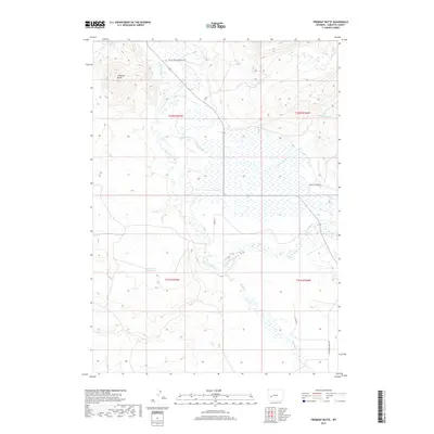
2017 Map of Fremont Butte
USGS Topo · Published 2017About this map
Fremont Butte rises above a high-desert landscape defined by the branching waters of the East Fork River and its numerous tributaries. This 2017 survey by the U.S. Geological Survey captures a sparsely populated region of Sublette County, where water resources are central to the landscape's utility and character. The presence of the Lander Cut-off Reservoir and various creeks such as Cottonwood Cr and Silver Cr highlight the vital role of drainage in this arid basin. Local infrastructure is largely tied to ranching and land management, evidenced by routes like Silver Creek Cemetery Rd and Mathis Ln. Notable thermal features, such as Steele Hot Springs, indicate the unique geothermal activity present in this corner of Wyoming, while the network of unpaved roads like E Fork Big Sandy Rd serves the remote grazing lands and wilderness access points.
Find a feature on this map
18 named features on this map. Tap any name to fly to it.
Don’t see what you’re looking for? This feature index may not catch every label — zoom into the map to look around manually.
Map Details
Editions of this 2017 Fremont Butte Map
This is the sole edition of this map. No revisions or reprints were ever made.
Other maps of this area

1938 · Mt Bonneville
USGS Topo · 1:62,500

1941 · Mt Bonneville
USGS Topo · 1:62,500

1942 · Mt Bonneville
USGS Topo · 1:62,500

1955 · Lander
USGS Topo · 1:250,000

1958 · Lander
USGS Topo · 1:250,000

1961 · Lander
USGS Topo · 1:250,000

1964 · Fremont Butte
USGS Topo · 1:24,000
1964 · Square Top
USGS Topo · 1:24,000

1964 · Boulder Lake
USGS Topo · 1:24,000

1964 · Boulder
USGS Topo · 1:24,000