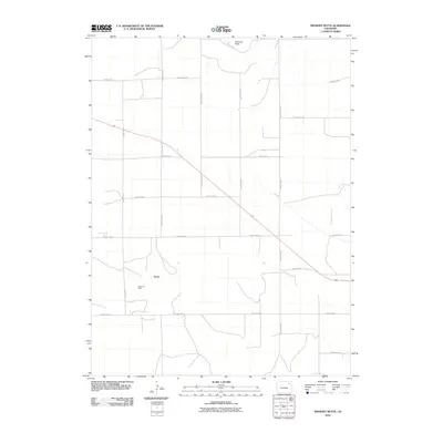
2010 Map of Fremont Butte
USGS Topo · Published 2010About this map
Xenia sits at the heart of this Washington County landscape, a small settlement defined by the geometric precision of the High Plains survey grid. The surrounding area is primarily characterized by the Xenia Oil Field, which marks the local extraction industry that has shaped the region's modern economy. Toward the north, Fremont Butte rises as a prominent topographical landmark above the plains, providing a natural focal point in a territory otherwise dominated by straight-line section roads such as County Rd 46 and County Road W. In the eastern portion of the quadrangle, the drainage of Twentytwo Slough introduces a rare aquatic feature to this dry environment, cutting a winding path through the otherwise orderly agricultural and industrial parcels.
Find a feature on this map
17 named features on this map. Tap any name to fly to it.
Don’t see what you’re looking for? This feature index may not catch every label — zoom into the map to look around manually.
Map Details
Editions of this 2010 Fremont Butte Map
This is the sole edition of this map. No revisions or reprints were ever made.
Other maps of this area

1951 · Merino SW
USGS Topo · 1:24,000

1951 · Merino SE
USGS Topo · 1:24,000

1954 · Sterling
USGS Topo · 1:250,000

1958 · Sterling
USGS Topo · 1:250,000

1973 · Akron
USGS Topo · 1:24,000

1973 · Rago
USGS Topo · 1:24,000

1973 · Fremont Butte
USGS Topo · 1:24,000

1973 · Pinneo SE
USGS Topo · 1:24,000
1973 · Buffalo Springs Ranch
USGS Topo · 1:24,000
1973 · Pinneo
USGS Topo · 1:24,000