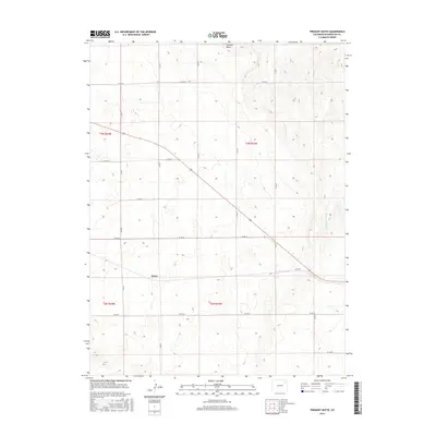
2016 Map of Fremont Butte
USGS Topo · Published 2016About this map
Xenia sits at the heart of this high plains landscape, defined by the geometry of the Public Land Survey System and the agricultural road network of Washington County. The terrain is marked by the prominence of Fremont Butte in the north, providing a rare vertical landmark in an area otherwise characterized by steady contour gradients. To the east, the drainage of Twentytwo Slough cuts through the township lines, illustrating the subtle hydrologic patterns of the region. A dense grid of county thoroughfares, including Co Rd 46 and Co Rd V, connects the scattered farmsteads across the townships of T3N and T2N, showing the persistent land-use patterns of Colorado's eastern plains into the twenty-first century.
Find a feature on this map
20 named features on this map. Tap any name to fly to it.
Don’t see what you’re looking for? This feature index may not catch every label — zoom into the map to look around manually.
Map Details
Editions of this 2016 Fremont Butte Map
This is the sole edition of this map. No revisions or reprints were ever made.
Other maps of this area

1951 · Merino SW
USGS Topo · 1:24,000

1951 · Merino SE
USGS Topo · 1:24,000

1954 · Sterling
USGS Topo · 1:250,000

1958 · Sterling
USGS Topo · 1:250,000

1973 · Akron
USGS Topo · 1:24,000

1973 · Rago
USGS Topo · 1:24,000

1973 · Fremont Butte
USGS Topo · 1:24,000

1973 · Pinneo SE
USGS Topo · 1:24,000
1973 · Buffalo Springs Ranch
USGS Topo · 1:24,000
1973 · Pinneo
USGS Topo · 1:24,000