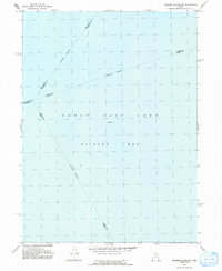
1991 Map of Fremont Island SW
USGS Topo · Published 1991About this map
Gilbert Bay occupies the central expanse of this 1991 survey, representing a significant portion of the Great Salt Lake during the late twentieth century. This specific quadrangle is defined by its lack of terrestrial features, focusing instead on the intersection of several municipal boundaries beneath the waterline. The map serves as a cartographic record of political geography in a shifting aqueous environment, where an Indefinite Boundary separates the jurisdictions of several counties. The survey notes an Elevation 4200 for the lake surface, a crucial data point for understanding the water levels of the era. The convergences of Box Elder Co Weber Co, Weber Co Davis Co, and Davis Co Tooele Co highlight the complex administrative divisions that partition the lake bed.
Find a feature on this map
8 named features on this map. Tap any name to fly to it.
Don’t see what you’re looking for? This feature index may not catch every label — zoom into the map to look around manually.
Map Details
Editions of this 1991 Fremont Island SW Map
This is the sole edition of this map. No revisions or reprints were ever made.
Other maps of this area

1885 · Tooele Valley
USGS Topo · 1:250,000

1953 · Tooele
USGS Topo · 1:250,000

1954 · Brigham City
USGS Topo · 1:250,000

1955 · Fremont Island
USGS Topo · 1:24,000

1955 · Tooele
USGS Topo · 1:250,000

1958 · Brigham City
USGS Topo · 1:250,000

1962 · Brigham City
USGS Topo · 1:250,000

1968 · Promontory Point
USGS Topo · 1:24,000

1968 · Plug Peak NW
USGS Topo · 1:24,000

1968 · Fremont Island SW
USGS Topo · 1:24,000