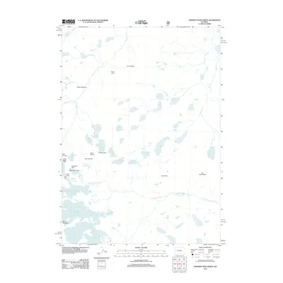
2012 Map of Fremont Peak North
USGS Topo · Published 2012About this map
Mount Sacagawea and the surrounding high-altitude terrain of the Wind River Range define this alpine landscape, where massive ice fields and sharp granite summits congregate. The hydrology is dominated by an extensive glacial system, including the Sacagawea Glacier, Lower Fremont Glacier, and Upper Fremont Glacier, which feed high-mountain waters like Klondike Lake and the various branches of Dinwoody Cr. High-elevation crossings such as Indian Pass, Backpackers Pass, and Blaurock Pass provide passage between the drainage basins of Dry Cr and N Fork Bull Lake Cr. Significant landmarks like Chimney Rock and Turret Peak rise above the meadows and moraines, while Horse Ridge and Dry Creek Ridge provide prominent natural boundaries in this 2012 survey. The map details the intricate network of meltwater streams and seasonal snowfields that characterize one of the most glaciated regions in the American West.
Find a feature on this map
32 named features on this map. Tap any name to fly to it.
Don’t see what you’re looking for? This feature index may not catch every label — zoom into the map to look around manually.
Map Details
Editions of this 2012 Fremont Peak North Map
This is the sole edition of this map. No revisions or reprints were ever made.
Other maps of this area

1909 · Fremont Peak
USGS Topo · 1:125,000

1952 · Hays Park
USGS Topo · 1:24,000

1952 · Bob Lakes
USGS Topo · 1:24,000

1952 · Alpine Lake
USGS Topo · 1:24,000

1955 · Thermopolis
USGS Topo · 1:250,000

1958 · Thermopolis
USGS Topo · 1:250,000

1962 · Thermopolis
USGS Topo · 1:250,000
1968 · Ink Wells
USGS Topo · 1:24,000

1968 · Fremont Peak North
USGS Topo · 1:24,000
1968 · Gannett Peak
USGS Topo · 1:24,000