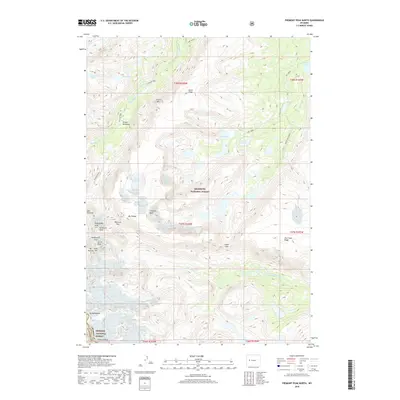
2018 Map of Fremont Peak North
USGS Topo · Published 2018About this map
Fremont Peak and Mt Sacagawea anchor the high-altitude divide between the Shoshone National Forest and Bridger National Forest in this 2018 survey. The landscape is defined by massive granite features and glacial hydrology, including the Heep Steep Glacier and the headwaters of N Fork Bull Lake Cr. For those tracing historical access through this part of the Wind River Range, the Glacier Trail provides the primary corridor, passing through Wilson Meadows and skirting the base of Fourts Horn. The map documents a complex alpine environment where naming conventions honor early explorers and notable local figures, while topographic markers like Horse Ridge and Dry Creek Ridge delineate the sharp relief of the Continental Divide's eastern slopes. Natural landmarks such as the Ink Wells and Noel Lake are also clearly located for modern spatial reference.
Find a feature on this map
43 named features on this map. Tap any name to fly to it.
Don’t see what you’re looking for? This feature index may not catch every label — zoom into the map to look around manually.
Map Details
Editions of this 2018 Fremont Peak North Map
This is the sole edition of this map. No revisions or reprints were ever made.
Other maps of this area

1909 · Fremont Peak
USGS Topo · 1:125,000

1952 · Hays Park
USGS Topo · 1:24,000

1952 · Bob Lakes
USGS Topo · 1:24,000

1952 · Alpine Lake
USGS Topo · 1:24,000

1955 · Thermopolis
USGS Topo · 1:250,000

1958 · Thermopolis
USGS Topo · 1:250,000

1962 · Thermopolis
USGS Topo · 1:250,000
1968 · Ink Wells
USGS Topo · 1:24,000

1968 · Fremont Peak North
USGS Topo · 1:24,000
1968 · Gannett Peak
USGS Topo · 1:24,000