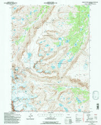
1991 Map of Fremont Peak North
USGS Topo · Published 1997About this map
Fitzpatrick Wilderness and the Shoshone National Forest dominate this high-elevation landscape, where ice and rock define the terrain. The map documents an extensive glacial system along the Continental Divide, including the Gannett Glacier, Dinwoody Glacier, and Helen Glacier. These ice fields feed a network of alpine water bodies such as Klondike Lake and the headwaters of Bull Lake Creek. Notable summits like Fremont Peak, Mount Sacagawea, and Mount Warren rise sharply between the glacial basins, marking the crest of the Wind River Range. The absence of roads and the presence of only a single Trail underscores the preservation of this remote area as it appeared during the late twentieth century. Significant landmarks such as Chimney Rock and high-altitude crossings like Indian Pass and Backpackers Pass provide essential orientation points for understanding the drainage patterns of the North Fork Bull Lake Creek and the surrounding peaks.
Find a feature on this map
45 named features on this map. Tap any name to fly to it.
Don’t see what you’re looking for? This feature index may not catch every label — zoom into the map to look around manually.
Map Details
Editions of this 1991 Fremont Peak North Map
This is the sole edition of this map. No revisions or reprints were ever made.
Other maps of this area

1909 · Fremont Peak
USGS Topo · 1:125,000

1952 · Hays Park
USGS Topo · 1:24,000

1952 · Bob Lakes
USGS Topo · 1:24,000

1952 · Alpine Lake
USGS Topo · 1:24,000

1955 · Thermopolis
USGS Topo · 1:250,000

1958 · Thermopolis
USGS Topo · 1:250,000

1962 · Thermopolis
USGS Topo · 1:250,000
1968 · Ink Wells
USGS Topo · 1:24,000

1968 · Fremont Peak North
USGS Topo · 1:24,000
1968 · Gannett Peak
USGS Topo · 1:24,000