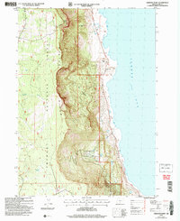
2004 Map of Fremont Point
USGS Topo · Published 2007About this map
The Fremont National Forest dominates this landscape, defined by the sharp vertical contrast between high alpine ridges and the basin of Summer Lake. Perched at a significant vantage point, the Fremont Point Fire Lookout Tower overlooks the dramatic drop of Winter Ridge, where the terrain falls away toward the lake's edge. This area is characterized by its complex hydrology, featuring numerous water sources like Cronin Well, Squirrel Spring, and the Ana River, which are vital in this high-desert environment.
Find a feature on this map
20 named features on this map. Tap any name to fly to it.
Don’t see what you’re looking for? This feature index may not catch every label — zoom into the map to look around manually.
Map Details
Editions of this 2004 Fremont Point Map
This is the sole edition of this map. No revisions or reprints were ever made.
Other maps of this area

1955 · Klamath Falls
USGS Topo · 1:250,000

1958 · Klamath Falls
USGS Topo · 1:250,000

1966 · Summer Lake
USGS Topo · 1:24,000

1966 · Shake Butte
USGS Topo · 1:24,000

1966 · Slide Mtn
USGS Topo · 1:24,000

1966 · Harvey Creek
USGS Topo · 1:24,000

1966 · Fremont Point
USGS Topo · 1:24,000

1966 · Pole Butte
USGS Topo · 1:24,000

1966 · Foster Butte
USGS Topo · 1:24,000

1974 · Lake Abert
USGS Topo · 1:100,000