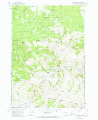
1967 Map of French Gulch
USGS Topo · Published 1972About this map
Burnt River carves a deep path through the canyonlands of eastern Oregon in this late-1960s survey. The landscape is defined by its verticality and water resources, as dozens of named springs such as Salt Spring No 1 and Tule Spring dot the drainages within the Whitman National Forest. The presence of a Gaging Station and Bennett Reservoir underscores the importance of water management in this arid mountain environment. Prospecting history is etched into the terrain near the river, where scattered Mines and Prospects suggest a legacy of mineral exploration. From the high elevations of Chicken Peak and Stump Spring Butte down to the Bridgeport Valley, the map details a network of jeep trails and canyons like Dark Canyon and Dead Horse Canyon, revealing a working landscape of timber, cattle, and ore.
Find a feature on this map
55 named features on this map. Tap any name to fly to it.
Don’t see what you’re looking for? This feature index may not catch every label — zoom into the map to look around manually.
Map Details
Editions of this 1967 French Gulch Map
3 editions found
Other maps of this area

1901 · Baker City
USGS Topo · 1:125,000

1955 · Baker
USGS Topo · 1:250,000

1959 · Baker
USGS Topo · 1:250,000

1964 · Bridgeport
USGS Topo · 1:62,500

1964 · Ironside
USGS Topo · 1:62,500

1967 · Encina
USGS Topo · 1:24,000

1967 · French Gulch
USGS Topo · 1:24,000

1967 · Dooley Mtn
USGS Topo · 1:24,000

1967 · Lost Basin
USGS Topo · 1:24,000
1967 · Bowen Valley
USGS Topo · 1:24,000