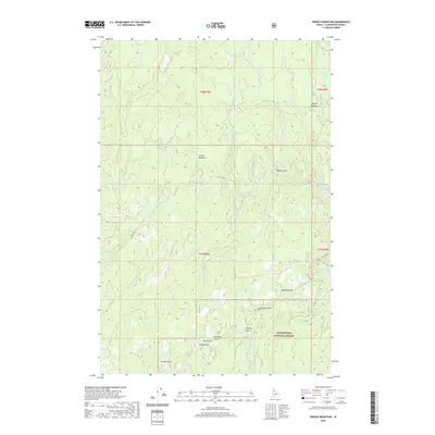
2020 Map of French Mountain
USGS Topo · Published 2020About this map
Clearwater National Forest encompasses the entirety of this Idaho landscape, which is defined by a dense network of drainages feeding into larger water bodies. The terrain is notably marked by numerous named gulches concentrated in the southern sections, including Business Gulch, Fidelity Gulch, and China Gulch. These features, along with high-elevation clearings like Oxford Meadows and Arnett Meadows, reflect the historical land-use patterns of the Bitterroot Mountains, where narrow canyons and mountain passes shaped early access and resource extraction. Significant elevation is marked at French Mtn, while the map reveals the layout of forest access via Shanghai Rd and French Mountain Rd. The complex hydrology of the area is illustrated by the confluence of Orogrande Cr, Rhodes Cr, and French Cr, providing a detailed look at the drainage basins within the Clearwater basin during the early twenty-first century.
Find a feature on this map
37 named features on this map. Tap any name to fly to it.
Don’t see what you’re looking for? This feature index may not catch every label — zoom into the map to look around manually.
Map Details
Editions of this 2020 French Mountain Map
This is the sole edition of this map. No revisions or reprints were ever made.
Other maps of this area

1923 · Washington Creek
USGS Topo · 1:125,000

1924 · Weippe
USGS Topo · 1:125,000

1938 · Headquarters
USGS Topo · 1:48,000

1944 · Headquarters
USGS Topo · 1:62,500

1956 · Hamilton
USGS Topo · 1:250,000

1959 · Hamilton
USGS Topo · 1:250,000

1960 · Hamilton
USGS Topo · 1:250,000

1963 · Clarke Mtn
USGS Topo · 1:24,000

1964 · Hamilton
USGS Topo · 1:250,000
1965 · Larch Butte
USGS Topo · 1:24,000