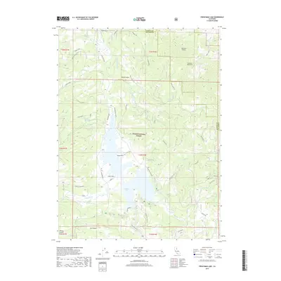
2018 Map of Frenchman Lake
USGS Topo · Published 2018About this map
Frenchman Lake serves as the focal point of this high-altitude landscape in the Plumas National Forest, where the reservoir's complex shoreline is marked by prominent features like Turkey Point and Lunker Point. The surrounding terrain is defined by the steep rises of the Diamond Mountains to the east and a network of drainages including Little Last Chance Cr and Ramelli Creek. Recreation and infrastructure are well-established, evidenced by the Big Cove East CG, East-Tract CG, and the Frenchman Dam Vista. On the northern edge of the sheet, the presence of the Bodad Airport and roads like Frenchman Blvd and Dooley Canyon Way highlight how human activity has adapted to this mountain environment, providing access to remote springs such as Dixie Spring and Dotta Spring.
Find a feature on this map
45 named features on this map. Tap any name to fly to it.
Don’t see what you’re looking for? This feature index may not catch every label — zoom into the map to look around manually.
Map Details
Editions of this 2018 Frenchman Lake Map
This is the sole edition of this map. No revisions or reprints were ever made.
Other maps of this area

1886 · Honey Lake
USGS Topo · 1:250,000

1890 · Sierraville
USGS Topo · 1:125,000

1891 · Honey Lake
USGS Topo · 1:250,000

1892 · Sierraville
USGS Topo · 1:125,000

1893 · Honey Lake
USGS Topo · 1:250,000

1894 · Sierraville
USGS Topo · 1:125,000

1950 · Chilcoot
USGS Topo · 1:62,500

1950 · Portola
USGS Topo · 1:62,500

1950 · Milford
USGS Topo · 1:62,500

1954 · Doyle
USGS Topo · 1:62,500