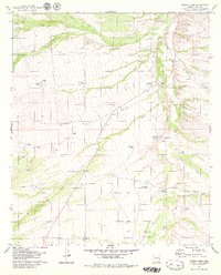
1979 Map of Fresno Wash
USGS Topo · Published 1979About this map
Fresno Wash and Altar Wash dominate this arid landscape in Pima County, where drainage networks define the terrain between Cerro Prieto and the surrounding plains. The 1970s cattle and ranching infrastructure is highly visible, centered around Pozo Nuevo Ranch and several family-named water sources like San Rafael Well. A complex system of stock tanks, including Pozo Nuevo Tank, Lilly Tank, and Pajonal Tank, illustrates the critical importance of water management in this desert environment. Human activity is marked by a network of jeep trails, a Gaging Station on the Altar Wash, and a remote Landing Strip. The map also captures the wash confluence at Bolas Blancas, a junction where Batamote Wash meets the Altar system, reflecting the seasonal hydrology of the region.
Find a feature on this map
36 named features on this map. Tap any name to fly to it.
Don’t see what you’re looking for? This feature index may not catch every label — zoom into the map to look around manually.
Map Details
Editions of this 1979 Fresno Wash Map
3 editions found
Other maps of this area

1920 · Arivaca
USGS Topo · 1:125,000

1940 · Palo Alto Ranch
USGS Topo · 1:62,500

1941 · Presumido Peak
USGS Topo · 1:62,500

1941 · Baboquivari Peak
USGS Topo · 1:62,500

1941 · Arivaca
USGS Topo · 1:62,500

1943 · Fresnal
USGS Topo · 1:125,000

1943 · Arivaca
USGS Topo · 1:62,500

1943 · Palo Alto Ranch
USGS Topo · 1:62,500

1943 · Presumido Peak
USGS Topo · 1:62,500

1944 · Baboquivari Peak
USGS Topo · 1:62,500