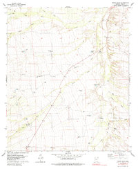
1979 Map of Fresno Wash
USGS Topo · Published 1985About this map
Fresno Wash and Altar Wash converge in this arid corridor of Pima County, shaping a landscape defined by seasonal watercourses and remote ranching outposts. Recorded through 1970s aerial photography, the map reveals a desert economy centered on groundwater management, evidenced by the proliferation of named catchment systems like Pozo Hondo Tank, Lilly Tank, and Pajonal Tank. Small-scale habitation is limited to established holdings such as Espinosa Ranch and Pozo Nuevo Ranch, while a lone Landing Strip and the Batamote Road provide the primary links across the basin. The presence of a Gaging Station and a Gravel Pit indicates the active monitoring of desert hydrology and local resource extraction during this era. Dominating the eastern horizon, the prominence of Cerro Prieto serves as a landmark above the complex network of distributaries including San Juan Wash and Bolas Blancas Wash.
Find a feature on this map
42 named features on this map. Tap any name to fly to it.
Don’t see what you’re looking for? This feature index may not catch every label — zoom into the map to look around manually.
Map Details
Editions of this 1979 Fresno Wash Map
3 editions found
Other maps of this area

1920 · Arivaca
USGS Topo · 1:125,000

1940 · Palo Alto Ranch
USGS Topo · 1:62,500

1941 · Presumido Peak
USGS Topo · 1:62,500

1941 · Baboquivari Peak
USGS Topo · 1:62,500

1941 · Arivaca
USGS Topo · 1:62,500

1943 · Fresnal
USGS Topo · 1:125,000

1943 · Arivaca
USGS Topo · 1:62,500

1943 · Palo Alto Ranch
USGS Topo · 1:62,500

1943 · Presumido Peak
USGS Topo · 1:62,500

1944 · Baboquivari Peak
USGS Topo · 1:62,500