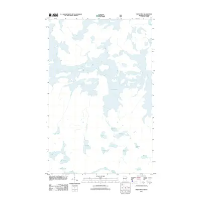
2011 Map of Friday Bay
USGS Topo · Published 2011About this map
Crooked Lake dominates the northern half of this borderlands survey, its intricate shoreline and many islands defining a landscape of interconnected water and dense forest. This territory in the Superior National Forest region along the Minnesota-Ontario border is a wilderness of significant water bodies, linked by drainages like Papoose Creek and Sinneeg Creek. The lack of road infrastructure or permanent settlements underscores the primitive state of the area, which remains primarily accessible by water. South of the main lake body, a cluster of smaller lakes including Papoose Lake, Chippewa Lake, and the remote Ritual Lake highlight the glacial geography. To the southwest, Beartrap Lake and Thunder Lake provide additional points of interest for those tracking historical portage routes and wilderness landmarks in this secluded northern reach.
Find a feature on this map
20 named features on this map. Tap any name to fly to it.
Don’t see what you’re looking for? This feature index may not catch every label — zoom into the map to look around manually.
Map Details
Editions of this 2011 Friday Bay Map
This is the sole edition of this map. No revisions or reprints were ever made.
Other maps of this area

1957 · Basswood Lake
USGS Topo · 1:62,500

1957 · Quetico
USGS Topo · 1:250,000

1963 · Fourtown Lake
USGS Topo · 1:24,000
1963 · Angleworm Lake
USGS Topo · 1:24,000
1963 · Friday Bay
USGS Topo · 1:24,000
1963 · Iron Lake
USGS Topo · 1:24,000

1968 · Quetico
USGS Topo · 1:250,000
1976 · Basswood Lake SW
USGS Topo · 1:24,000
1976 · Basswood Lake NW
USGS Topo · 1:24,000

1977 · Basswood Lake
USGS Topo · 1:100,000