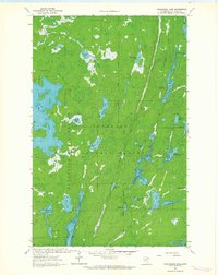
1963 Map of Angleworm Lake
USGS Topo · Published 1964About this map
Superior National Forest and Burntside State Forest converge in this northern Minnesota wilderness, mapped just as modern conservation efforts were formalizing the character of the Boundary Waters area. The landscape is defined by an intricate network of glacial lakes and waterways, including the elongated Angleworm Lake, the Hegman lakes, and the sprawling Stuart Swamp. Civil works are sparse, centered primarily on the Echo Trail corridor which provides the only major land access through the timber. A notable landmark for early forest management is the Angleworm Lookout Tower, situated on a high point above the lakes. This survey also records human intersections with the terrain through a few designated campsites and local features like Pictured Rock on North Hegman Lake, reflecting the region's transition into a destination for specialized wilderness recreation.
Find a feature on this map
36 named features on this map. Tap any name to fly to it.
Don’t see what you’re looking for? This feature index may not catch every label — zoom into the map to look around manually.
Map Details
Editions of this 1963 Angleworm Lake Map
2 editions found
Other maps of this area

1933 · Ely
USGS Topo · 1:62,500

1939 · Ely
USGS Topo · 1:62,500

1954 · Two Harbors
USGS Topo · 1:250,000

1954 · Hibbing
USGS Topo · 1:250,000

1954 · International Falls
USGS Topo · 1:250,000

1956 · Crab Lake
USGS Topo · 1:24,000

1957 · Two Harbors
USGS Topo · 1:250,000

1957 · Hibbing
USGS Topo · 1:250,000

1957 · International Falls
USGS Topo · 1:250,000

1957 · Quetico
USGS Topo · 1:250,000