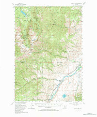
1955 Map of Fridley Peak
USGS Topo · Published 1984About this map
Gallatin National Forest dominates this mid-century landscape, where the high peaks of the Gallatin Range meet the valley of the Yellowstone River. The map highlights a transition from rugged alpine terrain, featuring numerous waterfalls like Palisade Falls and Grotto Falls, to the agricultural and transportation corridor in the southeast. Along the river, the Northern Pacific railroad tracks run parallel to the water, passing near the settlement of Merriman and the Historical Marker at the edge of the valley.
Find a feature on this map
78 named features on this map. Tap any name to fly to it.
Don’t see what you’re looking for? This feature index may not catch every label — zoom into the map to look around manually.
Map Details
Editions of this 1955 Fridley Peak Map
4 editions found

Other maps of this area

1888 · Three Forks
USGS Topo · 1:250,000

1891 · Livingston
USGS Topo · 1:250,000

1893 · Livingston
USGS Topo · 1:250,000

1894 · Three Forks
USGS Topo · 1:250,000

1895 · Three Forks
USGS Topo · 1:250,000

1947 · Bozeman
USGS Topo · 1:250,000

1948 · Bozeman
USGS Topo · 1:250,000

1951 · Bozeman Pass
USGS Topo · 1:62,500

1951 · Chimney Rock
USGS Topo · 1:24,000

1953 · Bozeman
USGS Topo · 1:62,500