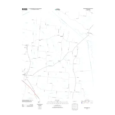
2013 Map of Friendship
USGS Topo · Published 2013About this map
Friendship serves as a primary hub within this agricultural landscape of West Tennessee, where the North Fork Forked Deer River and Middle Fork Forked Deer River define the local topography. This early 21st-century survey documents a network of rural settlements including Tigrett, Eaton, and Elizabeth, connected by a web of local roads named for prominent families and landmarks. The naming convention of thoroughfares such as Mays Cemetery Rd, Jimmy White Rd, and Dolan Smith Rd provides valuable clues for genealogists tracking long-standing property lines and community associations in Crockett County. The drainage patterns of Stokes Cr, Miller Cr, and Odell Cr illustrate the intricate water systems that have historically supported the region's farming economy.
Find a feature on this map
84 named features on this map. Tap any name to fly to it.
Don’t see what you’re looking for? This feature index may not catch every label — zoom into the map to look around manually.
Map Details
Editions of this 2013 Friendship Map
This is the sole edition of this map. No revisions or reprints were ever made.
Other maps of this area

1939 · Dyersburg
USGS Topo · 1:62,500

1939 · Halls
USGS Topo · 1:62,500

1952 · Bonicord
USGS Topo · 1:24,000

1952 · Newbern
USGS Topo · 1:24,000

1952 · Chestnut Bluff
USGS Topo · 1:24,000

1956 · Dyersburg
USGS Topo · 1:250,000

1956 · Blytheville
USGS Topo · 1:250,000

1959 · Blytheville
USGS Topo · 1:250,000

1961 · Halls
USGS Topo · 1:62,500
1961 · Dyersburg
USGS Topo · 1:62,500