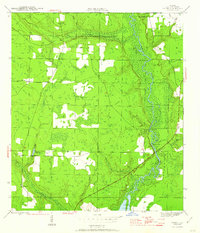
1945 Map of Frink
USGS Topo · Published 1960About this map
Chipola River meanders through this portion of Calhoun County, defining a landscape of low-lying wetlands and landing sites. During the mid-1940s, the river served as a vital corridor for local movement, marked by riverfront points such as Smith Landing and Carter Landing. The map reflects a rural community anchored by small settlements like Frink and Kinard, where life was centered around local institutions such as Frink Ch and the Abe Springs Sch.
Find a feature on this map
26 named features on this map. Tap any name to fly to it.
Don’t see what you’re looking for? This feature index may not catch every label — zoom into the map to look around manually.
Map Details
Editions of this 1945 Frink Map
3 editions found
Other maps of this area

1944 · Clarksville
USGS Topo · 1:31,680

1945 · Dead Lake
USGS Topo · 1:31,680

1945 · Juniper Creek
USGS Topo · 1:31,680

1945 · Blountstown
USGS Topo · 1:31,680

1945 · Clarksville
USGS Topo · 1:31,680

1945 · Broad Branch
USGS Topo · 1:31,680

1945 · Estiffanulga
USGS Topo · 1:31,680

1945 · Orange
USGS Topo · 1:31,680

1945 · Frink
USGS Topo · 1:31,680

1945 · Tenmile Swamp
USGS Topo · 1:31,680