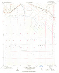
1956 Map of Frink
USGS Topo · Published 1957About this map
Salton Sea waters dominate this mid-century landscape, revealing a unique intersection of recreation, transportation, and military activity. Along the northeastern shore, the Southern Pacific railroad runs parallel to the waterline, serving small rail-side settlements like Frink and Pope. The map highlights a significant military footprint during the Cold War era, including a designated Sea Plane Landing Area and several large parcels of the Naval Reservation extending into the basin. These restricted zones sit adjacent to the developing Salton Sea State Park near Bombay, illustrating the dual-purpose nature of the shoreline at this time. Inland features such as Frink Spring and various Gravel Pit operations suggest the desert's resource-driven economy, while the precise measurement of 235 feet below sea level underscores the extreme topography of the Imperial Valley.
Find a feature on this map
20 named features on this map. Tap any name to fly to it.
Don’t see what you’re looking for? This feature index may not catch every label — zoom into the map to look around manually.
Map Details
Editions of this 1956 Frink Map
3 editions found
Other maps of this area

1940 · Kane Spring
USGS Topo · 1:62,500

1940 · Frink
USGS Topo · 1:62,500

1940 · Durmid
USGS Topo · 1:62,500

1944 · Durmid
USGS Topo · 1:62,500

1944 · Kane Spring
USGS Topo · 1:62,500

1944 · Calipatria
USGS Topo · 1:62,500

1944 · Frink
USGS Topo · 1:62,500

1954 · Salton Sea
USGS Topo · 1:250,000

1955 · Salton Sea
USGS Topo · 1:250,000

1956 · Frink NW
USGS Topo · 1:24,000