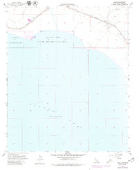
1956 Map of Frink
USGS Topo · Published 1979About this map
Salton Sea dominates the southwestern portion of this desert landscape, where the shoreline and water levels were measured at 230 feet below sea level during the late 1970s. The inland sea is bordered by the Salton Sea State Recreation Area, a focal point for regional leisure that sits adjacent to the residential grid of Bombay Beach. This desert community represents a specific era of mid-century development along the eastern shore, positioned just below the arid foothills of the Imperial Valley.
Find a feature on this map
11 named features on this map. Tap any name to fly to it.
Don’t see what you’re looking for? This feature index may not catch every label — zoom into the map to look around manually.
Map Details
Editions of this 1956 Frink Map
3 editions found
Other maps of this area

1940 · Kane Spring
USGS Topo · 1:62,500

1940 · Frink
USGS Topo · 1:62,500

1940 · Durmid
USGS Topo · 1:62,500

1944 · Durmid
USGS Topo · 1:62,500

1944 · Kane Spring
USGS Topo · 1:62,500

1944 · Calipatria
USGS Topo · 1:62,500

1944 · Frink
USGS Topo · 1:62,500

1954 · Salton Sea
USGS Topo · 1:250,000

1955 · Salton Sea
USGS Topo · 1:250,000

1956 · Frink NW
USGS Topo · 1:24,000