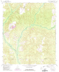
1972 Map of Frisco City SE
USGS Topo · Published 1984About this map
The boundary between Monroe, Conecuh, and Escambia counties defines this southern Alabama landscape as it appeared in the early 1970s. The terrain is characterized by the winding path of Big Escambia Creek and Escambia Creek, which feed into the broader drainage network of the region. A significant landmark for fire detection in the timbered hills is the Wild Fork Lookout Tower, situated near the Monroe-Conecuh county line. The presence of the Old Railroad Grade running through the northwestern and southwestern sections indicates the remnants of former logging or industrial rail lines that once moved through these woods. Near the southern edge, the small settlement of Dean sits close to the Escambia County border, while Corter Creek flows through the undulating topography of the north. This survey, updated with 1981 aerial data, preserves the rural character of the land before modern developments changed the local forest and water management patterns.
Find a feature on this map
8 named features on this map. Tap any name to fly to it.
Don’t see what you’re looking for? This feature index may not catch every label — zoom into the map to look around manually.
Map Details
Editions of this 1972 Frisco City SE Map
2 editions found
Other maps of this area

1953 · Andalusia
USGS Topo · 1:250,000

1957 · Andalusia
USGS Topo · 1:250,000

1960 · Huxford
USGS Topo · 1:24,000

1960 · Barnett Crossroads
USGS Topo · 1:24,000

1960 · Wallace
USGS Topo · 1:24,000

1971 · Range
USGS Topo · 1:24,000

1971 · Repton
USGS Topo · 1:24,000

1972 · Frisco City
USGS Topo · 1:24,000

1972 · Frisco City SE
USGS Topo · 1:24,000

1972 · Uriah East
USGS Topo · 1:24,000