1980 Map of Fristoe
USGS Topo · Published 1986About this map
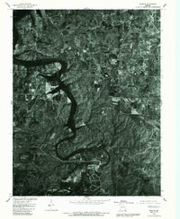
The community of Fristoe serves as a primary reference point in this 1980 orthophotoquad, which captures the rural landscape of Hickory County through high-altitude aerial photography. Unlike traditional topographic maps, this orthophotograph displays the actual vegetation patterns and field clearings across the region. The small settlements of Avery and White Cloud are visible, connected by a network of local roads that wind through the densely wooded terrain. The imagery highlights a significant river system meandering through the center of the quadrangle, where the sharp contrast between the dark water and the sunlit hillsides reveals the complex drainage patterns of the area. This document is particularly valuable for researchers looking to examine specific land use and clearing practices as they existed in the early 1980s.
Find a feature on this map
5 named features on this map. Tap any name to fly to it.
Don’t see what you’re looking for? This feature index may not catch every label — zoom into the map to look around manually.
Map Details
Editions of this 1980 Fristoe Map
This is the sole edition of this map. No revisions or reprints were ever made.
Other maps of this area

1884 · Bolivar
USGS Topo · 1:125,000

1887 · Warsaw
USGS Topo · 1:125,000

1892 · Bolivar
USGS Topo · 1:125,000

1894 · Warsaw
USGS Topo · 1:125,000

1935 · Edwards
USGS Topo · 1:24,000

1935 · Dell
USGS Topo · 1:24,000

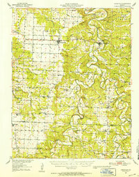
1945 · Fristoe
USGS Topo · 1:62,500

1947 · Jefferson City
USGS Topo · 1:250,000
1951 · Hermitage
USGS Topo · 1:62,500

1954 · Jefferson City
USGS Topo · 1:250,000