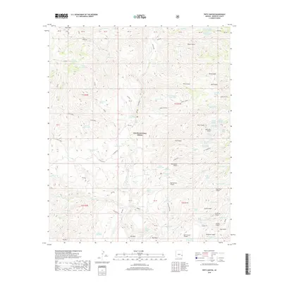
2018 Map of Fritz Canyon
USGS Topo · Published 2018About this map
Blue River carves a deep path through the heart of the Apache National Forest in this Greenlee County survey. The landscape is defined by an intricate network of drainages and named canyons, including Fritz Canyon, Wild Bunch Canyon, and Rock Tank Canyon. These steep corridors lead to prominent high points such as Alder Peak and High Mesa, while expansive flats like Pat Mesa provide rare level ground in a territory dominated by vertical relief.
Find a feature on this map
102 named features on this map. Tap any name to fly to it.
Don’t see what you’re looking for? This feature index may not catch every label — zoom into the map to look around manually.
Map Details
Editions of this 2018 Fritz Canyon Map
This is the sole edition of this map. No revisions or reprints were ever made.
Other maps of this area

1902 · Clifton
USGS Topo · 1:62,500

1913 · Morenci
USGS Topo · 1:125,000

1915 · Morenci
USGS Topo · 1:125,000

1954 · Clifton
USGS Topo · 1:250,000

1957 · Clifton
USGS Topo · 1:250,000

1958 · Clifton
USGS Topo · 1:250,000

1962 · Clifton
USGS Topo · 1:250,000

1962 · Clifton
USGS Topo · 1:62,500

1962 · Big Lue Mts
USGS Topo · 1:62,500
1967 · Alma Mesa
USGS Topo · 1:24,000