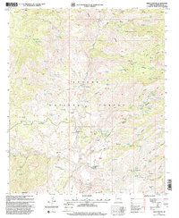
1997 Map of Fritz Canyon
USGS Topo · Published 2000About this map
The canyonlands of Apache National Forest are documented here during the late twentieth century, centered on the corridor of the Blue River. The landscape is defined by its working ranching history, evidenced by a dense network of specialized stock-raising infrastructure such as Xxx Ranch, Stacy Ranch, and numerous family-named or location-specific enclosures like Joe Fritz Corral and Lower Wild Bunch Corral. This distribution of corrals and tanks, including Winter Camp Tank and Buckhorn Canyon Tank, illustrates a survival-based land use pattern where water management was essential for maintaining herds across the varied elevations of Alder Peak and Pat Mountain. The map also captures the isolation of high-country dwellings like the Horse Canyon Cabin and the Cienega Corral Cabin, providing a precise look at the rural Arizona interior before further modernization.
Find a feature on this map
119 named features on this map. Tap any name to fly to it.
Don’t see what you’re looking for? This feature index may not catch every label — zoom into the map to look around manually.
Map Details
Editions of this 1997 Fritz Canyon Map
This is the sole edition of this map. No revisions or reprints were ever made.
Other maps of this area

1902 · Clifton
USGS Topo · 1:62,500

1913 · Morenci
USGS Topo · 1:125,000

1915 · Morenci
USGS Topo · 1:125,000

1954 · Clifton
USGS Topo · 1:250,000

1957 · Clifton
USGS Topo · 1:250,000

1958 · Clifton
USGS Topo · 1:250,000

1962 · Clifton
USGS Topo · 1:250,000

1962 · Clifton
USGS Topo · 1:62,500

1962 · Big Lue Mts
USGS Topo · 1:62,500
1967 · Alma Mesa
USGS Topo · 1:24,000