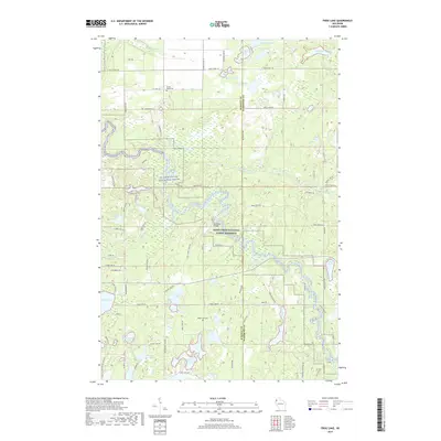
2019 Map of Frog Lake
USGS Topo · Published 2019About this map
The Saint Croix National Scenic Riverway dominates the central landscape of this western Wisconsin survey, where the river's winding path is joined by the Totagatic River and Webb Creek. This glaciated region is defined by an intricate network of small lakes and marshes, from the larger waters of Webb Lake and Saginaw Lake to smaller pockets like Frog Lake and Prinel Lake. Local history is anchored at the Webb Lake Cemetery and Forest Home Cemetery, providing specific points of interest for genealogists tracking early families in Burnett and Washburn counties. The rural infrastructure of the late 2010s is represented by crossings like the McDowel Bridge and a dense web of fire trails and country roads, including the Saint Croix Trail and Five Mile Road, which navigate the wetlands and wooded terrain.
Find a feature on this map
62 named features on this map. Tap any name to fly to it.
Don’t see what you’re looking for? This feature index may not catch every label — zoom into the map to look around manually.
Map Details
Editions of this 2019 Frog Lake Map
This is the sole edition of this map. No revisions or reprints were ever made.
Other maps of this area

1947 · Minong
USGS Topo · 1:48,000

1948 · Spooner
USGS Topo · 1:48,000

1949 · Hertel
USGS Topo · 1:48,000

1949 · Minong
USGS Topo · 1:48,000

1949 · Webb Lake
USGS Topo · 1:48,000

1949 · Spooner
USGS Topo · 1:48,000

1953 · Ashland
USGS Topo · 1:250,000

1953 · Duluth
USGS Topo · 1:250,000

1953 · Rice Lake
USGS Topo · 1:250,000

1953 · Stillwater
USGS Topo · 1:250,000